Woodbine Gardens
History:
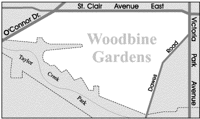
The Woodbine Gardens neighbourhood is located on the former site of the Woodbine Golf and Country Club which operated at this location during the 1930s. The Woodbine clubhouse was situated where Glenwood Crescent is today.
In 1932 the Woodbine Bridge was built across the Don Valley Ravine at a cost of two hundred and seventy-five thousand dollars. This bridge paved the way for the future development of Woodbine Gardens. The first house built in this neighbourhood was the Mary Pickford Bungalow situated at 90 Glenwood Crescent. This house was built in 1943 to raise money for the Canadian war effort. A raffle was held for the Pickford bungalow with tickets selling for only $1.00 a share. Mary Pickford, the Toronto-born Hollywood screen star, donated her time and money to this patriotic cause.
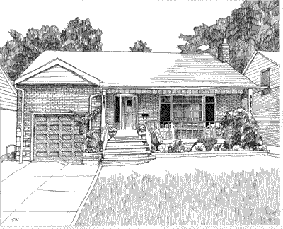
The building of the Woodbine Gardens subdivision in the early 1950s was a major engineering feat. Watercourses had to be rerouted underground and 500,000 cubic yards of soil were removed in order to level many of the hills in this area. Woodbine Gardens houses which originally sold for between $14,000 and $19,000.
Ed Note: The Woodbine Bridge is one of Toronto’s largest bridges. It measures eight hundred and ten feet long and forty-six feet wide.
Overview:
When you drive through Woodbine Gardens with its hills and dales and winding and sloping crescents it is easy to envision the fact that this neighbourhood was once an attractive golf course. The wonderful geography of the Woodbine Gardens neighbourhood is further complemented by Taylor Creek Park which wraps itself around the southern reaches of this neighbourhood.
Lifestyle:
Taylor Creek Park, located at the south end of this neighbourhood, is a picturesque woodland and wetland valley that is perfect for walking and exploring nature. Taylor Creek Park is part of a ten-kilometre walking trail that stretches from Warden Avenue in the east to Edwards Gardens at the west end of the trail. Access points to Taylor Creek Park are located throughout this neighbourhood.
George Webster Park, situated along Chapman Avenue has baseball diamonds, sports fields, and a children’s playground. There is also an outdoor natural ice rink that operates at this park during the wintertime. Donora Park, located east of Dawes Road, has a tots playground. The moderate size hills in this park are good for tobogganing in the wintertime.
The Dawes Road branch of the East York public library is located at 416 Dawes Road. This library offers a variety of programs for children.
Homes:
The charming brick and stone houses on Glenwood Crescent were built in the 1940’s. All the other houses in the neighbourhood were built in the early 1950’s. House styles range from Tudor and ranch-style bungalows to solid brick two-storey houses. Most of these homes are situated on generous size lots with a private drive and a garage.
Rexleigh Drive features some low-rise rental apartment buildings while Dawes Road has a number of high-rise rental apartment buildings that command a scenic view of Taylor Creek Park.
Recreation:
Taylor Creek Park, located at the south end of this neighbourhood, is a picturesque woodland and wetland valley that is perfect for walking and exploring nature. Taylor Creek Park is part of a ten-kilometre walking trail that stretches from Warden Avenue in the east to Edwards Gardens at the west end of the trail. Access points to Taylor Creek Park are located throughout this neighbourhood.
George Webster Park, situated along Chapman Avenue has baseball diamonds, sports fields, and a children’s playground. There is also an outdoor natural ice rink that operates at this park during the wintertime. Donora Park, located east of Dawes Road, has a tots playground. The moderate size hills in this park are good for tobogganing in the wintertime.
The Dawes Road branch of the East York public library is located at 416 Dawes Road. This library offers a variety of programs for children.
Transportation:
This neighbourhood is served by bus lines on Woodbine, Victoria Park and St. Clair Avenues as well as on Dawes Road, Ferris Road and Rexleigh Drive. These bus routes connect to either the Coxwell, Main, Woodbine, or Victoria Park subway stations on the Bloor-Danforth subway line.
Motorists are approximately five minutes from the Don Valley Parkway on-ramp at O’Connor and Don Mills Road. This highway provides motorists with quick access to the downtown core as well as connecting routes to the major highways north of the city.
Featured Listings
Woodbine Gardens Stats
Walkability:
Low
Bikeability:
Low
Public Transit:
Low
Affordability:
Medium
Greenspace:
Medium
Recreation:
Medium
Legend: Low, Medium, High
Commute Times
* All commuting times provided are approximate times only. Commute times may increase or decrease depending on where you live within the neighbourhood and the time of day i.e rush hour versus off hour commutes. Time estimates to public transit are based on walking distance or bus line connection whichever is quicker. All other commute times on the chart above are based on drive times.
School Guide
No Records Found
Sorry, no records were found. Please adjust your search criteria and try again.
Google Map Not Loaded
Sorry, unable to load Google Maps API.
Toronto School Resources

Editor’s Note. BEFORE MOVING INTO, BUYING OR RENTING A HOME, PLEASE CONTACT THE SCHOOL YOU ARE CONSIDERING BY PHONE to ensure your home is within the designated boundaries and that your child is age appropriate. WE CANNOT BE HELD RESPONSIBLE FOR ANY MISINFORMATION REGARDING SCHOOL ENROLLMENT SO DO NOT ASSUME that your child can automatically attend a specific school or specialized program until you have official confirmation from that school. Please visit the school board web sites for more information.