Regal Heights
History:
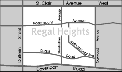
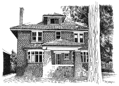
Regal Heights was settled in 1818, by an Irishman from Tipperary County, by the name of Bartholomew Bull. Bull was responsible for building Davenport Road, which was originally known as “Bull’s Road”. Bulls’ second house, built in 1830, was called “Springmount”. This was the first brick building in York Township, and as such was considered quite a novelty in its early years. Springmount was descriptively named after a water course that once meandered down the Davenport escarpment in front of the Bulls’ homestead. Springmount remained in the possession of the Bull family until the estate was sold to developers in 1910. The Springmount name has been perpetuated in Springmount Avenue, which is one of the signature streets in the Regal Heights neighbourhood.
Overview:
The Regal Heights neighbourhood is situated on the western crest of the Davenport escarpment. This neighbourhood has many distinguishing characteristics including very large turn of the century houses, winding tree- lined streets, and an elevation atop the Davenport escarpment that offers many home owners unparalleled views of the Toronto skyline.
Lifestyle:
Regal Heights is located at the edge of the ïCorso Italia’ shopping district along St. Clair Avenue West. This area has a lively Italian atmosphere that features some of the city’s best Italian restaurants and cafes. ïCorso Italia’ is also known for its fashion and accessory stores.
Homes:
Regal Heights detached and semi-detached three storey houses were built between 1912 and 1923. These homes feature many traditional charms including oak trim, beamed ceilings, stained and leaded glass windows, hardwood floors, and fireplaces. Some of the larger Regal Heights homes have been converted into multi-plex dwellings.
Recreation:
Regal Heights is located at the edge of the ïCorso Italia’ shopping district along St. Clair Avenue West. This area has a lively Italian atmosphere that features some of the city’s best Italian restaurants and cafes. ïCorso Italia’ is also known for its fashion and accessory stores.
Transportation:
The Regal Heights neighbourhood is well served by public transit. The St. Clair streetcar is within walking distance of every home, and additional bus service is available on Oakwood Avenue, Dupont Street, and Bathurst Street. Motorists are approximately ten minutes from downtown Toronto and from the Allen Expressway which links commuters to Toronto’s major highways.
Featured Listing
Featured Listings
Regal Heights Stats
Walkability:
Medium
Bikeability:
Low
Public Transit:
Medium
Affordability:
Medium
Greenspace:
Low
Recreation:
Medium
Legend: Low, Medium, High
Commute Times
* All commuting times provided are approximate times only. Commute times may increase or decrease depending on where you live within the neighbourhood and the time of day i.e rush hour versus off hour commutes. Time estimates to public transit are based on walking distance or bus line connection whichever is quicker. All other commute times on the chart above are based on drive times.
School Guide
No Records Found
Sorry, no records were found. Please adjust your search criteria and try again.
Google Map Not Loaded
Sorry, unable to load Google Maps API.
Toronto School Resources

Editor’s Note. BEFORE MOVING INTO, BUYING OR RENTING A HOME, PLEASE CONTACT THE SCHOOL YOU ARE CONSIDERING BY PHONE to ensure your home is within the designated boundaries and that your child is age appropriate. WE CANNOT BE HELD RESPONSIBLE FOR ANY MISINFORMATION REGARDING SCHOOL ENROLLMENT SO DO NOT ASSUME that your child can automatically attend a specific school or specialized program until you have official confirmation from that school. Please visit the school board web sites for more information.