Silverthorn
History:
The Silverthorn neighbourhood is named after Aaron Silverthorn who settled here with his wife and three sons in 1825. The old Silverthorn homestead was located high on a hill near the present-day Silverthorn and Eglinton Avenues. Aaron’s son, Francis, inherited his father’s property and turned it into a successful cattle farm. Francis was also a pioneer in dietetics and healthy living. He made honey and salt- free biscuits and sold these products under the banner of the “Silverthorn Honey and Hardtack Company.” Francis Silverthorn died in 1894 at the age of seventy-nine. The former Silverthorn farm was opened up for residential development in 1914 under the name Silverthorn Heights. Sales were brisk and the subdivision filled in very quickly. However, it wasn’t until the late 1920’s that Silverthorn residents would receive the basic city services such as water, sewers, and paved roads that they enjoy today.
Overview:
Silverthorn is a working class neighbourhood filled with affordable homes within a reasonable commuting distance of downtown Toronto. Silverthorn has an established Italian community as well as being home to many new Canadians from a myriad of different backgrounds. Silverthorn’s hilly terrain is the distinguishing feature of this neighbourhood. The predominantly one way streets that twist and wind through Silverthorn’s gently rolling hills are a refreshing change from the grid-like street pattern common in so many Toronto neighbourhoods.
Lifestyle:
The main shopping thoroughfare in Silverthorn is situated along Eglinton Avenue West. This shopping area lined with two-storey commercial buildings is known as Little Jamaica. The Westside Mall, on Eglinton Avenue at Caledonia Road, is anchored by national department and grocery stores. Rogers Road also has a fairly busy retail strip that includes the Black Creek Super Value Shopping Centre just west of Keele Street.
Homes:
The majority of Silverthorn houses were built between 1914 and 1930. These modest brick and frame houses include two-storey detached and semi-detached houses as well as storey-and-a-half and bungalow detached houses. Silverthorn houses have an old world charm as they sit perched upon gently rolling hills in a village like setting.
Recreation:
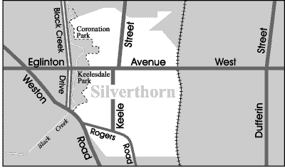
A cluster of recreational activities are available in the Black Creek Drive and Eglinton Avenue area. The Centennial building at 2694 Eglinton Avenue East has an indoor swimming pool as well as being the home of a local historical museum. There are four large public parks located along Black Creek Drive near Eglinton Avenue. Starting at the north end, Trethewey Park is a nature revitalization area on the banks of the Black Creek. This is an ideal spot for picnic goers and nature enthusiasts. Coronation Park is a mix of sports and leisure. This park has a T-Ball and Softball leagues as well as two tennis courts, a children’s playground and a woodland trail. North and South Keelesdale Park feature large sports fields and baseball diamonds. The Chris Tonks Ice Arena is also situated in South Keelesdale Park.
The Silverthorn Public Library, at 1748 St. Clair Avenue West is famous for appearing on the opening sequence of the syndicated Book Mice television show. Children from all over Canada and as far away as the United States have stopped in to visit the home of the book mice. The staff at this library even conduct a Book Mice Tour much to the delight of the children who visit here.
Transportation:
The Keele Street and Rogers Road buses connect to the Keele and Ossington stations on the Bloor-Danforth subway line. The Eglinton Avenue bus connects to the Eglinton station on the Yonge-University-Spadina subway line. Motorists can get to downtown Toronto’s financial and entertainment districts in approximately twenty minutes using Keele Street, which is the main north-south street running through Silverthorn. For motorists travelling out of the city the Allen Expressway, off Eglinton Avenue, is approximately fifteen minutes from Silverthorn.
Featured Listings
Silverthorn Stats
Walkability:
Low
Bikeability:
Low
Public Transit:
Low
Affordability:
Medium
Greenspace:
Medium
Recreation:
Medium
Legend: Low, Medium, High
Commute Times
* All commuting times provided are approximate times only. Commute times may increase or decrease depending on where you live within the neighbourhood and the time of day i.e rush hour versus off hour commutes. Time estimates to public transit are based on walking distance or bus line connection whichever is quicker. All other commute times on the chart above are based on drive times.
School Guide
No Records Found
Sorry, no records were found. Please adjust your search criteria and try again.
Google Map Not Loaded
Sorry, unable to load Google Maps API.
Toronto School Resources

Editor’s Note. BEFORE MOVING INTO, BUYING OR RENTING A HOME, PLEASE CONTACT THE SCHOOL YOU ARE CONSIDERING BY PHONE to ensure your home is within the designated boundaries and that your child is age appropriate. WE CANNOT BE HELD RESPONSIBLE FOR ANY MISINFORMATION REGARDING SCHOOL ENROLLMENT SO DO NOT ASSUME that your child can automatically attend a specific school or specialized program until you have official confirmation from that school. Please visit the school board web sites for more information.