Emery
History:
Emery was originally settled by Issac Devins, a German pioneer who came to Canada from Pennsylvania in the 1790’s. Emery’s second settler, John Crosson walked here from Pennsylvania in 1799. The Crosson family belongings were carried on the back of a two year old horse that Crosson sold to Devins in exchange for half of the latter’s 200 acre farm lot.
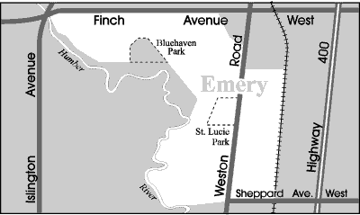
By the 1870’s, Emery had emerged as a farming hamlet at the crossroads of Finch Avenue and Weston Road. Emery had its own school, church, blacksmith shop and general store. A local post office opened in 1879 under the name “Dayton”. The Toronto Grey and Bruce Railway adopted the Dayton name for their flag station on Finch Avenue.
The post office and railway station later changed their name to Emery to avoid the inevitable confusion that arose between Dayton, Ontario and Dayton Ohio. No one is certain why the Emery name was chosen but it was readily adopted by the whole community.
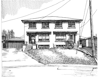
Emery’s rural existence came to an end in the 1960’s when developers built residential subdivisions and industry where farms once dotted this landscape. The former Emery School bell mounted in a cairn on the grounds of Emery Collegiate serves as a lonely reminder of the small town origins of this community.
Overview:
Emery is located in the north-west pocket of Toronto. It is bordered to the west by the majestic beauty of the Humber River Valley and to the east by the Canadian Pacific freight railway line. At the north end of this neighbourhood is the Milvan Drive commercial and industrial corridor that encompasses an eclectic mix of automobile sales and service shops, a church, wholesalers and importers, a shopping plaza with a Latin American theme, and a variety of specialty type businesses.
Emery is one of Toronto’s most culturally diverse neighbourhoods. The local high school has students from 45 different cultural backgrounds and the shopping districts are filled with a plethora of food shops that specialize in various cuisines from around the world.
Lifestyle:
If you are a food connoisseur and want to sample a variety of foods from around the world, Emery is a good place to shop. The strip malls on Finch Avenue and Weston Road are lined with food shops and restaurants that specialize in East and West Indian, African, Jamaican, Asian, European, Italian and Spanish foods.
The largest mall in the neighbourhood is the Finch West Mall at the corner of Finch Avenue and Weston Road. This mall has a McDonalds, a Canadian Tire, bargain stores, and medical and professional offices.
Homes:
Emery’s housing stock dates mostly from the 1960’s. The north and east pockets of the neighbourhood are filled with bungalow and two-storey solid brick semi-detached homes. All of these houses have private driveways and most also have a garage.
The houses west of Weston Road and south of St. Lucie Park are situated on streets named after places in Florida. Some of the street names here include: Coral Gable, Gulfstream, Hibiscus, Royal Palm, Tampa, Vero Beach and West Palm. Maybe it’s the street names, but these detached, ranch-style bungalows on the Humber Valley side of the neighbourhood have a certain Floridian ambience and appeal.
Recreation:
Emery residents can access the West Humber parkland at designated points south of Finch Avenue, and east of Islington Avenue. This park contains a 5.5 kilometre paved trail that follows the Humber River Valley to the Humber Arboretum which features a variety of plants and wildlife. There are also a number of pretty strolling parks found throughout this neighbourhood.
The Habitant Arena at 3383 Weston Road has a house hockey league for children, as well as shinny hockey and public skating. The Woodview Park public library is located at 16-18 Bradstock Road, at the Woodview Plaza.
Transportation:
The Finch Avenue bus connects passengers to the Finch station on the Yonge-University-Spadina subway line. The Weston Road bus connects to the Weston Go Train station and the Keele station on the Bloor-Danforth subway line.
Weston Road and Finch Avenue are the main arterial roadways in the neighbourhood. Weston Road will link motorists to the central corridor of the city, while Finch Avenue links up with Toronto’s major north-south arterial roadways. For those travelling out of the city Highways 400 and 401 are each approximately five minutes away.
Emery Stats
Walkability:
Medium
Bikeability:
Medium
Public Transit:
Medium
Affordability:
Medium
Greenspace:
Medium
Recreation:
Medium
Legend: Low, Medium, High
Commute Times
* All commuting times provided are approximate times only. Commute times may increase or decrease depending on where you live within the neighbourhood and the time of day i.e rush hour versus off hour commutes. Time estimates to public transit are based on walking distance or bus line connection whichever is quicker. All other commute times on the chart above are based on drive times.
School Guide
No Records Found
Sorry, no records were found. Please adjust your search criteria and try again.
Google Map Not Loaded
Sorry, unable to load Google Maps API.
Toronto School Resources

Editor’s Note. BEFORE MOVING INTO, BUYING OR RENTING A HOME, PLEASE CONTACT THE SCHOOL YOU ARE CONSIDERING BY PHONE to ensure your home is within the designated boundaries and that your child is age appropriate. WE CANNOT BE HELD RESPONSIBLE FOR ANY MISINFORMATION REGARDING SCHOOL ENROLLMENT SO DO NOT ASSUME that your child can automatically attend a specific school or specialized program until you have official confirmation from that school. Please visit the school board web sites for more information.